Seeking Comments: Of the blogs we read, the most interesting attract a lot of comments. We note that many of those who respond do not use their real names. Heretofore we’ve had a policy of discarding anonymous messages. That’s ended. Use your name of you wish, but don’t hesitate to use any name or names you like. No limit on comments.
Whatcom officialdom is going through a process of determining where the expected number of future residents should live. It is estimated the county’s population will grow to over 251,000 by 2031. That’s approximately 60,000 more than present. (We round these numbers off to emphasize they are estimates, whereas the county’s calculators use numbers like 60,490.)
The state’s Growth Management Act requires counties to create their own growth plans, allocating expected growth to particular areas. Whatcom County is behind and losing out on six-figure state grants. A Growth Management Hearings Board told Whatcom to catch up by June 30. So last fall the County Council formed a Growth Management Coordinating Council to advise on deciding how many of the expected new residents should go where. That group consists of two county council members and the mayors of the seven cities in the county, but not representatives of the two unincorporated UGAs, Birch Bay and Columbia Valley.
The county planning department then began a series of community meetings with an informational website and questionnaires. Thursday, February 5, the Birch Bay Steering Committee sponsored a meeting with Gary Davis and Kate Koch of the planning department. Among their maps was one showing what land the planning department views as available for building.
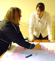
Informed members of the community found these maps wholly inaccurate. Bill Grant was outraged, citing his own and other properties colored as vacant that are approved and platted for development. Lisa Guthrie, who represents Homestead, was relaxed but nonetheless critical.
Koch and Davis were not devastated. Such happens, they explained, and kept smiling, passing out colored pencils for participants to mark up the large maps arranged conveniently on tables.
In a conversation a week later, Kate Koch (pronounced cook), when asked what medication she used to maintain equanimity, said, “Green tea is enough”.
She said that a few days after the meeting she went back to Birch Bay with staff and the map-makers to look at the questioned properties. Guthrie, as the representative of Homestead, seems to know all the available land in the UGA. She wrote to Koch in an e-mail that, “I do not feel we have near the physical capacity of density that has been assumed.”
If you split the difference between two annual growth rates used by the planners in this exercise (7.5 percent and 4.8 percent) to 6.2 percent and compound out 10 years from the estimated Birch Bay population last year (5,292), you come to 9,094 by 2018.
But this subject is akin to a white glove inspection of a platoon’s barracks before the soldiers ship overseas – purposeful but relatively insignificant because of uncertainty. What is important is that this exercise confronts the Birch Bay community with the need to decide its own future.
All comments are welcomed.
ak
Monday, February 16, 2009
Monday, February 2, 2009
Birch Bay learns from Lummi Island
In the 1980’s, one of the big geological questions was, “Is the Cascadia Subduction Zone magically greased?” The issue was, would it slide smoothly or stick dangerously, Brian Atwater told a large assemblage at the Lummi Island Grange Hall. Atwater is a geologist with the U.S. Geological Survey’s Earthquake Hazards Team.
“It’s a detective story, with the earth giving the clues”, Atwater said, as he showed a slide of a 2005 dig where layers of sand indicated when tsunamis had occurred in Sumatra, one about every 600 years. Forces at the epicenter in the Indian Ocean, stuck for hundreds of years, broke loose in December 2004 and created a 9.0 magnitude earthquake. Through uplift and subsidence, a series of immense waves wreaked havoc and devastation on millions of people. Had that geologist made her discovery a few years earlier, those people may have been warned of the possibility.
Ancient writings and trees rings solved another detective story. In 1700, Japan experienced an “orphan tsunami”. Six writings preserved from Japan described the “orphan tsunami”, the only one from 1536 to 1995 that could not be associated with perceivable “shaking” in Chile or Peru. However, dendrochronologist David Yamaguchi, working with Atwater at the University of Washington in 1997, proved through tree ring analysis that a massive earthquake occurred in the Cascadia Subduction Zone in 1700. The force was sufficient to explain the Japanese tsunami of the same year.
Following Atwater’s presentation, Terry Terry, chair of the Lummi Island Community Association that hosted the event, introduced Stacy Fawell, from the Department of Natural Resources of the Lummi Nation. She outlined the earthquake/tsunami preparation and mitigation steps taken by the Lummi Nation. Their multihazard mitigation plan, created with assistance from FEMA (Federal Emergency Management Agency), identifies and strategizes necessary efforts. They established and mapped tsunami evacuation routes with the help of the State Department of Natural Resources and posted evacuation route signs. They purchased and installed a tsunami warning system consisting of three siren towers.
To discuss the Lummi Island emergency preparations, Terry surprised John Granger, the director of Lummi Island’s emergency management activities, with an invitation to take the floor. He said he had observed the small villages outside the major cities affected by hurricane Katrina had to wait a long time for help. He asked Fire Chief Duncan McLane if Lummi Island was prepared for a similar event. He reports that Chief McLane said, “No we’re not, why don’t you take care of that?”
Bringing together the NGOs (non-government organizations), churches, water districts, and other community residents, several members attended a State Emergency Management Conference. There they learned about the Map Your Neighborhood concept. They decided on a three-step process for their island: first organize, then create maps and do table top exercises, and, finally, do a full community drill. He says they have been working on step one for three years, but actually, a large percentage of the island is mapped.
The group has identified: landing zones for sea and land planes; special hazards on the island such as the water reservoir above a residential development; Red Cross shelters (the Grange Hall being one, with an emergency kitchen); healthcare providers able to serve during an emergency; equipment and medications needed for a “push package” from the Wasjington State Department of Emergency Management. First Aid Training is going on now, and they are considering CERT (Community Emergency Response Team) training.
The Fire District leads Lummi Island’s Emergency Management program and they recommend every individual maintain a seven-day emergency kit of food, water and necessary supplies.
Kathy Berg, chair of the Birch Bay Steering Committee; Doralee Booth, vice-chair of the Steering Committee and chair of the Public Safety and Transportation Subcommittee, and Ruth Higgins, leader of the Emergency Preparedness Task Force attended at the invitation of Ms. Terry.
rah
Subscribe to:
Posts (Atom)